Can AI help bring wildlife back?

Can AI help bring wildlife back?

Sherbourne Valley Laser Scanning by Derek Lawrence

Using technology to advance our work

It seems like every day there is a new headline news story explaining how artificial intelligence (AI) is changing our world. It seems we sit on the verge of the next era, a period of change as profound as the industrial revolution. Advancement in technology can bring a lot of benefits but there are also well documented concerns relating to the impact AI can and will have on us as individuals and society.

Whilst it’s right to be aware of concerns relating to future technologies, it’s also important to explore whether they can help us achieve our aim of enabling nature’s recovery. In Warwickshire, and across the Wildlife Trust movement we are currently exploring how we can use different technologies in a positive way and we thought it would be interesting to share these examples with you.

Laser scanning and virtual reality

Our Sherbourne Valley Project, funded by the National Lottery Heritage Fund, is using laser scanning technology to help capture an accurate 3D picture of the river and its surroundings. We are collaborating with Twindl, a company specialising in ‘reality capture’ to create a digital copy of the river Sherbourne as it runs through the pipe beneath the city of Coventry. We are also creating a 3D digital replica, accurate to within 10mm, of Lakeview Park in Coventry and the river as it flows through it. Over the course of the project we’ll be working with contractors and volunteers to help re-naturalise the park, creating more ponds and restoring some of the river’s natural processes. We will then take another 3D scan of the park which will help to demonstrate the improvements made for nature and people.

3D laser scanning is an excellent tool for a number of reasons:

  • Provides dimensionally accurate copy of tricky organic shapes and spaces, enabling the creation of 3D models to understand how the land is formed.
  • Integrates photographic capture, giving you accurate 360 degree photo imagery of the site which can be explored in virtual reality.
  • Combining the points above we can accurately measure and interpret the existing context alongside the potential of future alterations.
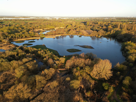
Brandon Marsh from the air

Brandon Marsh by Simon Watts

Satellite imagery data

Our Natural Capital Assessment Programme (formally Habitat Biodiversity Audit) is working with a company called SPOTTITT, who specialise in satellite imagery data capture and analysis. In June we commissioned the satellite imagery capture of the whole of Warwickshire Coventry and Solihull.

This gives us a more detailed ‘Google Maps-style aerial image’ of the whole region and is accurate to a 50cm resolution, meaning we can see trees within a hedgerow and where bramble is growing alongside.

'Once the satellite imagery has been
converted into habitat maps, we can use
that information to help inform our work'

The satellite imagery data is then converted into UK Habitat Classification (UKHAB) mapping data using machine learning artificial intelligence. The UKHAB is a new, free-to-use, unified and comprehensive approach to mapping and classifying habitats in UK. It allows every field or land parcel to be classified based on the habitats within it, creating a patchwork quilt of different habitats for the area. Prior to this technology being invented, the only way to capture this data was to go out and physically survey every field in the county to establish what habitats were where.

Once the satellite imagery has been converted into habitat maps, we can use that information to help inform our work. For example, it shows us where all of the woodland is, so if we’re looking to plant new woodland, we can identify the best locations to link up existing woodlands creating bigger, better, more joined up habitats for wildlife.

It also helps us to provide up to date information which can be used to measure and inform the impact of infrastructure projects, such as HS2, or feed into Council development consultations.

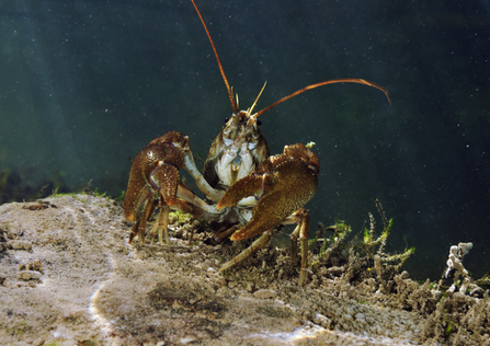
White-clawed crayfish

White-clawed crayfish by Linda Pitkin

eDNA profiling

Our Reviving our Wetlands project, funded by Natural England’s Species Recovery Fund, will be using environmental DNA (eDNA) analysis of water. Environmental DNA analysis works by detecting mitochondrial DNA, released from an organism into the environment where they live. This can be via secreted faeces, mucous, gametes, shed skin, hair and carcasses. Research has shown that the DNA of a range of aquatic organisms can be detected in water samples analysed in a laboratory. Prior to this technology the only way to establish what was in a water body was through an intensive survey programme conducted by people under license.

We will be working with Coventry City Council and Warwick University to take water samples from ponds across the area. The aim of this project will be to understand where native white clawed crayfish are present and where the non-native signal crayfish also occur. This information will help to inform our work to prioritise the conservation of white clawed crayfish, improve their habitat and create the conditions for them to thrive in new areas.